At time of publishing the winter storm has not arrived, please see updates at our website
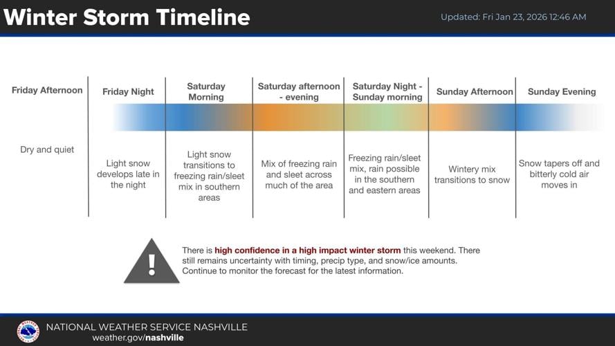
Wilson County is preparing for the coming winter storm conditions expected to begin late Friday night to early Saturday morning.
The National Weather Service office in Nashville issued a winter storm warning for most of Middle Tennessee, including Wilson County and surrounding counties on Thursday effective through Sunday evening.
The NWS says to expect power outages and tree damage due to ice accumulation, and if anyone needs to travel, keep an extra flashlight, food and water in their vehicles in case of an emergency, and latest road conditions can be obtained by calling 511.
Officials encourage people to stay home and keep off the roads unless it’s “absolutely necessary.”
All week long, meteorologists have been trying to predict the exact impacts of the storm; however, due to the shifting nature of the models used to forecast the weather, it has been hard to determine the greatest threat to the area.
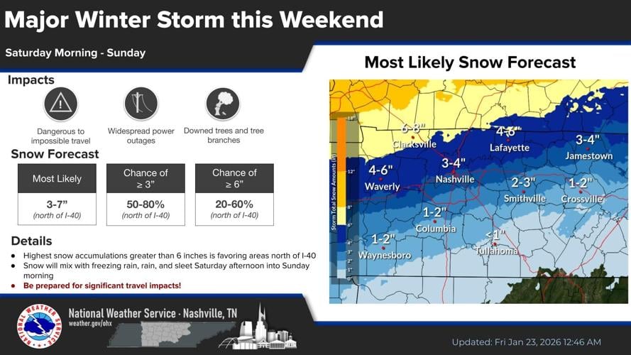
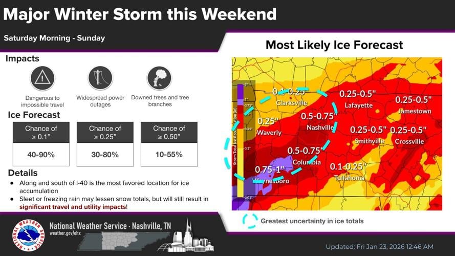
The NWS says heavy mixed precipitation is likely to happen. In Wilson County, the “most likely” snow forecast by the NWS is between two to four inches and ice accumulation between a quarter of an inch to half an inch. Highest chances for ice are south of Interstate-40, with highest snowfall chances north of I-40.
Wilson County Emergency Management Agency is preparing by reminding residents to keep extra blankets and clothing, charge electronic devices ahead of the storm and fill their vehicle’s gas tank.
“If you slide off the road or get involved in an accident, it may take first responders longer than usual to reach you due to road conditions,” WEMA said. “Please know Wilson County EMA and our partners have plans in place and will respond, but expect extended response times while crews navigate snow and ice safely.”
“If you don’t need to travel, this is your official permission to stay home, drink coffee, and binge your favorite show. The grocery store will still be there tomorrow.”
The Wilson County Warming Center will open Friday, Jan. 23 at 5 p.m. at the Wilson County Fairgrounds. According to WEMA, there is no set closing date or time. Hours will depend on temperatures and snowfall totals as this winter weather system develops.
WEMA asks people not to arrive at the fairgrounds prior to 5 p.m. as staff and volunteers will still be setting up and preparing the shelter.
“If you are experiencing homelessness or do not have a safe place to stay, we strongly encourage you to come to the shelter,” WEMA said. “Travel conditions may become dangerous, and it could be extremely difficult or take an extended amount of time for help to reach you on Saturday once the storm moves in.
Wilson County Schools are having a regular school day Friday, as no weather impacts to school operations were expected, according to WCS Public Information Officer Bart Barker.
“From there, we will await this incoming weekend winter storm and see exactly what we’re dealing with,” Barker said. “Are school closures possible for next week? Absolutely. Is it possible for multi-day closures? That’s very possible as well. Could there be little to no impacts? Not probable, but can’t be ruled out completely. We will wait and see the overall impacts of this storm and then district leadership will determine what’s next.”
Barker also said he will provide an update on Sunday regarding possible school closures for the early week while lingering effects from the storm are still in the county.
County officials are reminding residents that calling 911 should only be reserved for emergencies. The Cities of Lebanon, Mt. Juliet and Watertown say they are working to prepare to keep main roads as clear as possible for essential travel, such as first responders.
LPD Public Information Officer Zach Patton said checking on neighbors and animals will be important throughout the weekend.
“Make sure you have an emergency plan at your house,” Patton said. “It could be a challenging time for our community, it’s important that we rely on each other and check on each other as we go through this.”
The NWS is forecasting temperatures to drop below freezing (32 degrees Fahrenheit) beginning around 5 p.m. Friday and remaining below freezing throughout the next week—with the chance of highs reaching 33 degrees next Tuesday and Thursday.
Lows in the single digits and “feels like” reaching below zero are expected during the overnight hours between Monday and Tuesday.


(0) comments
Welcome to the discussion.
Log In
Keep it Clean. Please avoid obscene, vulgar, lewd, racist or sexually-oriented language.
PLEASE TURN OFF YOUR CAPS LOCK.
Don't Threaten. Threats of harming another person will not be tolerated.
Be Truthful. Don't knowingly lie about anyone or anything.
Be Nice. No racism, sexism or any sort of -ism that is degrading to another person.
Be Proactive. Use the 'Report' link on each comment to let us know of abusive posts.
Share with Us. We'd love to hear eyewitness accounts, the history behind an article.